
Bugaksan's Last Closed Trail Opens After 59 Years, 1.32 km Open 24 Hours
The final gate on the hill behind the Blue House has swung open. Since 9 a.m. on the 17th, a 1.32 km trail on Bugaksan's south-west side, facing Cheongun-dong, has been open to everyone, and like the rest of the mountain it never closes.
Why it stayed shut for 59 years
It goes back to Jan. 21, 1968, when North Korean commandos came down to attack the Blue House. Afterwards civilians were kept off Bugaksan and some 30 military posts and guard facilities went up.
Because the slope sits right behind the presidential compound, this south-west stretch was the last to be released.
Three openings, 6.52 km in total
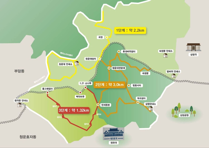
Bugaksan opened in stages: 2.2 km on the north side in 2020, 3.0 km on the south-east side in 2022, and now the final 1.32 km.
Add them up and the open trails total 6.52 km. The Presidential Security Service's map shows all three phases in yellow, orange and red on one sheet.
What the new section is like
The service built it mostly along the patrol paths soldiers already used, without damaging the landscape. From here you can look down on the Blue House grounds from behind.
The map marks the 1.21 Pine, Baegak Maru and Manse Dongbang along the way.
Open at night, with a safety net
Like the existing trails, the new section has no closing time. Patrols from the information centres and CCTV run alongside.
On the 7th, Jongno fire station, the Korea Forest Service, Jongno-gu Office and Jongno police held a joint wildfire drill on the section.
Who made it happen
The security service has been preparing since last July with the other agencies: new trail building, upgrades and safety measures. The Korea Heritage Service worked on the visitor environment of the scenic site Bugaksan, and Jongno-gu supported trail construction.
"With this phase 3 opening we have been able to return Bugaksan to the people in full," said PSS head Hwang In-kwon.
Before you go
The new section runs on the Cheongun-dong side and has no closing time.
The security service's phase 3 map shows the stages and the information centres.
Sources & context
2026-10-18T12:20:18.223Z
Munhwa Ilbo · The last trail on the hill behind the Blue House opens after 59 years (Oct. 13, 2026) ↗Aju Business Daily · The route sealed after the armed infiltration returns to citizens (Oct. 16, 2026) ↗Financial News · Bugaksan's last restricted zone opens after 59 years, open 24 hours from the 17th (Oct. 13, 2026) ↗The Electronic Times · The last closed Bugaksan trail opens from the 17th, Presidential Security Service says (Oct. 13, 2026; carries the PSS trail map) ↗Photo credit
대통령경호처 제공 · Press material supplied by the issuer for media use and published with its announcementMap of the Bugaksan trails: phase 1 (2.2 km), phase 2 (3.0 km) and the new phase 3 (1.32 km). Image: Presidential Security Service